


Mongrésin les étangs

Djaie60
User
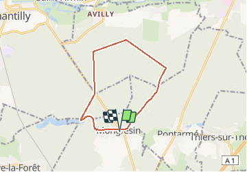

Length
10.5 km

Max alt
74 m

Uphill gradient
86 m
Km-Effort
11.7 km

Min alt
47 m

Downhill gradient
85 m
Boucle
Yes
Creation date :
2020-02-12 14:57:40.517
Updated on :
2020-02-12 14:58:31.815
--
Difficulty : Very easy

FREE GPS app for hiking
 SityTrail
IGN / Geographical institutes
SityTrail Plus
The world is yours!
About
Trail On foot of 10.5 km to be discovered at Hauts-de-France, Oise, Orry-la-Ville. This trail is proposed by Djaie60.
Positioning
Country:
France
Region :
Hauts-de-France
Department/Province :
Oise
Municipality :
Orry-la-Ville
Location:
Unknown
Start:(Dec)
Start:(UTM)
465078 ; 5444730 (31U) N.
Comments