


chemin yvrench

Martelpierre
User
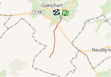

Length
3.5 km

Max alt
99 m

Uphill gradient
16 m
Km-Effort
3.7 km

Min alt
88 m

Downhill gradient
14 m
Boucle
Yes
Creation date :
2020-02-12 16:34:10.877
Updated on :
2020-02-12 20:05:24.825
44m
Difficulty : Very easy

FREE GPS app for hiking
 SityTrail
IGN / Geographical institutes
SityTrail Plus
The world is yours!
About
Trail Walking of 3.5 km to be discovered at Hauts-de-France, Somme, Gueschart. This trail is proposed by Martelpierre.
Positioning
Country:
France
Region :
Hauts-de-France
Department/Province :
Somme
Municipality :
Gueschart
Location:
Unknown
Start:(Dec)
Start:(UTM)
429872 ; 5565081 (31U) N.
Comments