


SityTrail - Pointoise Saint Ouen L'Aumone 17 km 17 02 2020

jpcccb
User
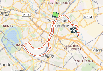

Length
15.3 km

Max alt
44 m

Uphill gradient
125 m
Km-Effort
16.9 km

Min alt
16 m

Downhill gradient
106 m
Boucle
No
Creation date :
2020-02-14 13:01:08.091
Updated on :
2024-01-31 10:52:14.688
3h50
Difficulty : Easy

FREE GPS app for hiking
 SityTrail
IGN / Geographical institutes
SityTrail Plus
The world is yours!
About
Trail On foot of 15.3 km to be discovered at Ile-de-France, Val-d'Oise, Pontoise. This trail is proposed by jpcccb.
Description
départ de la gare de Pontoise, Berges de l'Oise, Coulée verte aménagée de la Liesse, arrivée à Saint Ouen l'Aumone Liesse , bistrot.
Positioning
Country:
France
Region :
Ile-de-France
Department/Province :
Val-d'Oise
Municipality :
Pontoise
Location:
Unknown
Start:(Dec)
Start:(UTM)
433953 ; 5432964 (31U) N.
Comments