


Monchardon-Gonthier

crocau
User
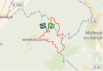

Length
6.4 km

Max alt
1173 m

Uphill gradient
429 m
Km-Effort
12.1 km

Min alt
752 m

Downhill gradient
439 m
Boucle
Yes
Creation date :
2020-02-15 14:58:31.033
Updated on :
2020-02-15 17:26:34.882
2h19
Difficulty : Very easy

FREE GPS app for hiking
 SityTrail
IGN / Geographical institutes
SityTrail Plus
The world is yours!
About
Trail Walking of 6.4 km to be discovered at Auvergne-Rhône-Alpes, Isère, Izeron. This trail is proposed by crocau.
Description
boucle avec gps car il a fallu emprunter des raccourci vers des vieux chemins..
Photos


Positioning
Country:
France
Region :
Auvergne-Rhône-Alpes
Department/Province :
Isère
Municipality :
Izeron
Location:
Unknown
Start:(Dec)
Start:(UTM)
689412 ; 5002291 (31T) N.
Comments
ça grimpe mais l'arrivée est jolie et redescente très sympa