


U Saint Emiland

clabidault
User
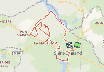

Length
11.4 km

Max alt
478 m

Uphill gradient
126 m
Km-Effort
13 km

Min alt
421 m

Downhill gradient
126 m
Boucle
Yes
Creation date :
2020-02-15 12:53:12.303
Updated on :
2020-02-15 20:03:03.845
2h47
Difficulty : Very easy

FREE GPS app for hiking
 SityTrail
IGN / Geographical institutes
SityTrail Plus
The world is yours!
About
Trail Walking of 11.4 km to be discovered at Bourgogne-Franche-Comté, Saône-et-Loire, Saint-Émiland. This trail is proposed by clabidault.
Positioning
Country:
France
Region :
Bourgogne-Franche-Comté
Department/Province :
Saône-et-Loire
Municipality :
Saint-Émiland
Location:
Unknown
Start:(Dec)
Start:(UTM)
613105 ; 5195652 (31T) N.
Comments