


randonnée Vasles

Arnaud Dejean
User
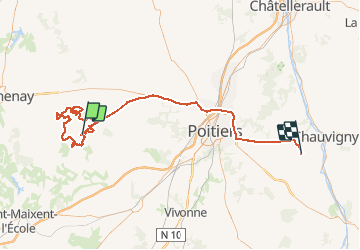

Length
107 km

Max alt
216 m

Uphill gradient
984 m
Km-Effort
121 km

Min alt
67 m

Downhill gradient
1030 m
Boucle
No
Creation date :
2020-02-16 06:56:44.693
Updated on :
2020-02-16 11:47:08.124
4h48
Difficulty : Medium

FREE GPS app for hiking
 SityTrail
IGN / Geographical institutes
SityTrail Plus
The world is yours!
About
Trail Mountain bike of 107 km to be discovered at New Aquitaine, Deux-Sèvres, Vasles. This trail is proposed by Arnaud Dejean.
Positioning
Country:
France
Region :
New Aquitaine
Department/Province :
Deux-Sèvres
Municipality :
Vasles
Location:
Unknown
Start:(Dec)
Start:(UTM)
728049 ; 5162106 (30T) N.
Comments