


Villedoux

ludol
User
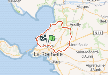

Length
44 km

Max alt
35 m

Uphill gradient
242 m
Km-Effort
47 km

Min alt
-3 m

Downhill gradient
243 m
Boucle
Yes
Creation date :
2020-02-16 09:53:40.211
Updated on :
2020-02-16 12:48:59.906
2h53
Difficulty : Easy

FREE GPS app for hiking
 SityTrail
IGN / Geographical institutes
SityTrail Plus
The world is yours!
About
Trail Mountain bike of 44 km to be discovered at New Aquitaine, Charente-Maritime, Lagord. This trail is proposed by ludol.
Description
Tour des marais de villedoux, canal et front de mer.
À faire par terrain sec, sinon c'est beaucoup plus difficile.
Positioning
Country:
France
Region :
New Aquitaine
Department/Province :
Charente-Maritime
Municipality :
Lagord
Location:
Unknown
Start:(Dec)
Start:(UTM)
642413 ; 5116646 (30T) N.
Comments