


cluny

Bonsaicd
User
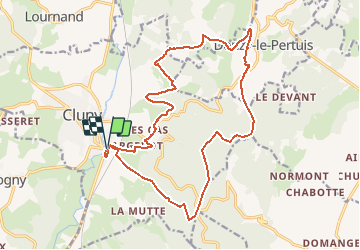

Length
20 km

Max alt
553 m

Uphill gradient
548 m
Km-Effort
27 km

Min alt
245 m

Downhill gradient
549 m
Boucle
Yes
Creation date :
2020-02-17 15:45:05.704
Updated on :
2020-02-17 15:48:47.436
--
Difficulty : Difficult

FREE GPS app for hiking
 SityTrail
IGN / Geographical institutes
SityTrail Plus
The world is yours!
About
Trail On foot of 20 km to be discovered at Bourgogne-Franche-Comté, Saône-et-Loire, Cluny. This trail is proposed by Bonsaicd.
Positioning
Country:
France
Region :
Bourgogne-Franche-Comté
Department/Province :
Saône-et-Loire
Municipality :
Cluny
Location:
Unknown
Start:(Dec)
Start:(UTM)
628053 ; 5142685 (31T) N.
Comments