


L'Ubaye classe 2 (3)

DaVinci
User
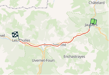

Length
14.8 km

Max alt
1213 m

Uphill gradient
51 m
Km-Effort
15.9 km

Min alt
1093 m

Downhill gradient
167 m
Boucle
No
Creation date :
2020-02-17 18:13:28.724
Updated on :
2020-02-17 18:14:36.454
2h30
Difficulty : Medium

FREE GPS app for hiking
 SityTrail
IGN / Geographical institutes
SityTrail Plus
The world is yours!
About
Trail Canoe - kayak of 14.8 km to be discovered at Provence-Alpes-Côte d'Azur, Alpes-de-Haute-Provence, Jausiers. This trail is proposed by DaVinci.
Positioning
Country:
France
Region :
Provence-Alpes-Côte d'Azur
Department/Province :
Alpes-de-Haute-Provence
Municipality :
Jausiers
Location:
Unknown
Start:(Dec)
Start:(UTM)
319247 ; 4920290 (32T) N.
Comments