


poix

libinsport
User

Length
175 km

Max alt
545 m

Uphill gradient
2705 m
Km-Effort
211 km

Min alt
359 m

Downhill gradient
2710 m
Boucle
No
Creation date :
2020-02-14 08:19:57.414
Updated on :
2020-02-18 12:09:46.92
99h32
Difficulty : Very easy

FREE GPS app for hiking
 SityTrail
IGN / Geographical institutes
SityTrail Plus
The world is yours!
About
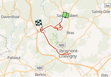
Trail Walking of 175 km to be discovered at Wallonia, Luxembourg, Saint-Hubert. This trail is proposed by libinsport.
Description
marche
Positioning
Country:
Belgium
Region :
Wallonia
Department/Province :
Luxembourg
Municipality :
Saint-Hubert
Location:
Hatrival
Start:(Dec)
Start:(UTM)
668221 ; 5541984 (31U) N.
Comments