


col de rosset

franquen
User
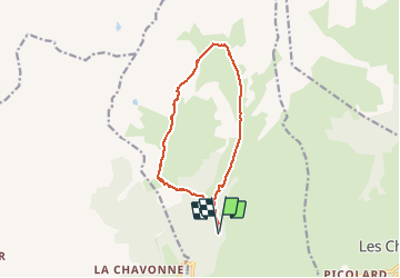

Length
13 km

Max alt
2337 m

Uphill gradient
925 m
Km-Effort
25 km

Min alt
1411 m

Downhill gradient
922 m
Boucle
Yes
Creation date :
2020-02-20 07:55:18.188
Updated on :
2020-02-20 13:51:51.141
4h23
Difficulty : Very easy

FREE GPS app for hiking
 SityTrail
IGN / Geographical institutes
SityTrail Plus
The world is yours!
About
Trail Touring skiing of 13 km to be discovered at Auvergne-Rhône-Alpes, Savoy, La Plagne-Tarentaise. This trail is proposed by franquen.
Positioning
Country:
France
Region :
Auvergne-Rhône-Alpes
Department/Province :
Savoy
Municipality :
La Plagne-Tarentaise
Location:
La Côte-d'Aime
Start:(Dec)
Start:(UTM)
318339 ; 5051309 (32T) N.
Comments