


SityTrail - Rémécourt 10km

Djaie60
User
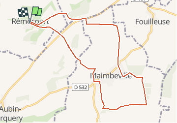

Length
9.6 km

Max alt
153 m

Uphill gradient
159 m
Km-Effort
11.7 km

Min alt
78 m

Downhill gradient
159 m
Boucle
Yes
Creation date :
2020-02-20 15:57:54.912
Updated on :
2020-02-20 15:58:37.419
--
Difficulty : Very easy

FREE GPS app for hiking
 SityTrail
IGN / Geographical institutes
SityTrail Plus
The world is yours!
About
Trail On foot of 9.6 km to be discovered at Hauts-de-France, Oise, Rémécourt. This trail is proposed by Djaie60.
Positioning
Country:
France
Region :
Hauts-de-France
Department/Province :
Oise
Municipality :
Rémécourt
Location:
Unknown
Start:(Dec)
Start:(UTM)
463282 ; 5475222 (31U) N.
Comments