


Saint-Julien (13 km - D. 260 m)

Thomasdanielle
User
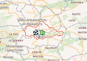

Length
12.6 km

Max alt
440 m

Uphill gradient
260 m
Km-Effort
16 km

Min alt
212 m

Downhill gradient
258 m
Boucle
Yes
Creation date :
2020-02-20 12:54:24.0
Updated on :
2020-02-21 10:47:40.576
3h09
Difficulty : Unknown

FREE GPS app for hiking
 SityTrail
IGN / Geographical institutes
SityTrail Plus
The world is yours!
About
Trail Walking of 12.6 km to be discovered at Auvergne-Rhône-Alpes, Rhône, Saint-Julien. This trail is proposed by Thomasdanielle.
Description
D/A Parking de la coopérative viticole
Positioning
Country:
France
Region :
Auvergne-Rhône-Alpes
Department/Province :
Rhône
Municipality :
Saint-Julien
Location:
Unknown
Start:(Dec)
Start:(UTM)
627341 ; 5098016 (31T) N.
Comments