


Cramans 20 février 2020 CAF

TRIMAILLE
User
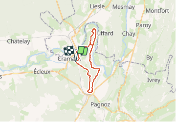

Length
19.9 km

Max alt
416 m

Uphill gradient
520 m
Km-Effort
27 km

Min alt
229 m

Downhill gradient
522 m
Boucle
Yes
Creation date :
2020-02-20 07:49:41.704
Updated on :
2021-02-02 15:59:37.73
6h11
Difficulty : Medium

FREE GPS app for hiking
 SityTrail
IGN / Geographical institutes
SityTrail Plus
The world is yours!
About
Trail Walking of 19.9 km to be discovered at Bourgogne-Franche-Comté, Jura, Cramans. This trail is proposed by TRIMAILLE.
Positioning
Country:
France
Region :
Bourgogne-Franche-Comté
Department/Province :
Jura
Municipality :
Cramans
Location:
Unknown
Start:(Dec)
Start:(UTM)
711776 ; 5209857 (31T) N.
Comments