


Bouillon, Côte d'Auclin

ramagufa
User
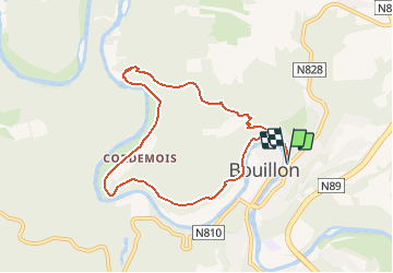

Length
7.6 km

Max alt
369 m

Uphill gradient
318 m
Km-Effort
11.8 km

Min alt
213 m

Downhill gradient
317 m
Boucle
Yes
Creation date :
2020-02-20 22:13:54.493
Updated on :
2020-02-20 22:17:05.226
2h00
Difficulty : Medium

FREE GPS app for hiking
 SityTrail
IGN / Geographical institutes
SityTrail Plus
The world is yours!
About
Trail On foot of 7.6 km to be discovered at Wallonia, Luxembourg, Bouillon. This trail is proposed by ramagufa.
Description
8 km au départ du Relais Godefroid, vers la côte d'Auclin pour atteindre le Belvédère puis le point de vue sur l'Abbaye de Clairfontaine. Revenir par le Moulin de l'Epine et retour en longeant la Semois.
Positioning
Country:
Belgium
Region :
Wallonia
Department/Province :
Luxembourg
Municipality :
Bouillon
Location:
Bouillon
Start:(Dec)
Start:(UTM)
649038 ; 5517969 (31U) N.
Comments