


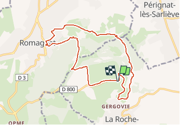
Gergovie le plateau de Gergovie

jeanic63
User

Length
9.6 km

Max alt
727 m

Uphill gradient
328 m
Km-Effort
13.9 km

Min alt
468 m

Downhill gradient
328 m
Boucle
Yes
Creation date :
2020-02-23 09:21:49.611
Updated on :
2020-02-23 09:27:27.428
--
Difficulty : Medium

FREE GPS app for hiking
 SityTrail
IGN / Geographical institutes
SityTrail Plus
The world is yours!
About
Trail On foot of 9.6 km to be discovered at Auvergne-Rhône-Alpes, Puy-de-Dôme, La Roche-Blanche. This trail is proposed by jeanic63.
Description
Départ parking le casque gaulois (vers le musée)
Positioning
Country:
France
Region :
Auvergne-Rhône-Alpes
Department/Province :
Puy-de-Dôme
Municipality :
La Roche-Blanche
Location:
Unknown
Start:(Dec)
Start:(UTM)
509823 ; 5062793 (31T) N.
Comments