


Coye la forêt

domifon
User
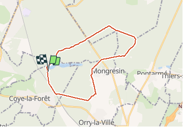

Length
13.5 km

Max alt
90 m

Uphill gradient
115 m
Km-Effort
15 km

Min alt
45 m

Downhill gradient
126 m
Boucle
Yes
Creation date :
2020-02-12 13:15:44.0
Updated on :
2020-02-23 09:42:55.83
2h30
Difficulty : Unknown

FREE GPS app for hiking
 SityTrail
IGN / Geographical institutes
SityTrail Plus
The world is yours!
About
Trail Nordic walking of 13.5 km to be discovered at Hauts-de-France, Oise, Coye-la-Forêt. This trail is proposed by domifon.
Description
Grande marche d’une après-midi avec Claudine Fernande et Domi
Positioning
Country:
France
Region :
Hauts-de-France
Department/Province :
Oise
Municipality :
Coye-la-Forêt
Location:
Unknown
Start:(Dec)
Start:(UTM)
462064 ; 5444744 (31U) N.
Comments