


St Sulpice de Faviere

pascal.dabet
User
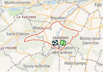

Length
12.4 km

Max alt
157 m

Uphill gradient
240 m
Km-Effort
15.6 km

Min alt
57 m

Downhill gradient
238 m
Boucle
Yes
Creation date :
2020-02-23 13:13:32.107
Updated on :
2020-02-23 16:32:12.265
3h17
Difficulty : Very easy

FREE GPS app for hiking
 SityTrail
IGN / Geographical institutes
SityTrail Plus
The world is yours!
About
Trail Walking of 12.4 km to be discovered at Ile-de-France, Essonne, Saint-Sulpice-de-Favières. This trail is proposed by pascal.dabet.
Positioning
Country:
France
Region :
Ile-de-France
Department/Province :
Essonne
Municipality :
Saint-Sulpice-de-Favières
Location:
Unknown
Start:(Dec)
Start:(UTM)
439079 ; 5376859 (31U) N.
Comments