Trail Touring skiing Pralognan-la-Vanoise - le Blanchon - Photo
 franquen
franquen

User

© OpenStreetMap contributors
Length
Length
16.1 km
Max alt
Max alt
2726 m
Uphill gradient
Uphill gradient
1333 m
Km-Effort
Km-Effort  
34 km
Min alt
Min alt
1441 m
Downhill gradient
Downhill gradient
1335 m
Boucle
Boucle
Yes
Creation date :
2020-02-23 07:29:26.992
Updated on :
2020-02-23 17:16:27.548

(0 Reviews)

Touring skiing
Touring skiing
6h58
Difficulty : Medium

Scan this QR Code to open this trail in the SityTrail application

FREE GPS app for hiking

Logo SityTrail SityTrail

IGN / Geographical institutes

Download SityTrail from the App Store Download SityTrail from Google Play

Logo SityTrail SityTrail Plus

The world is yours!

Download SityTrail from the App Store Download SityTrail from Google Play Download SityTrail on Huawei AppGallery

About

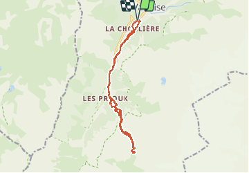
Trail Touring skiing of 16.1 km to be discovered at Auvergne-Rhône-Alpes, Savoy, Pralognan-la-Vanoise. This trail is proposed by franquen.

Description

Randonnée avec une approche très longue par la route vers les Prioux non déneigée. Mais superbe montée à partir des Prioux et belle descente.
Au simmet du Blanchon les derniers metres skis sur le dos car manque d'enneigement.

Elevation profile

Positioning

Country:
France
Region :
Auvergne-Rhône-Alpes
Department/Province :
Savoy
Municipality :
Pralognan-la-Vanoise
Location:
Unknown
Start:(UTM)
321351 ; 5027171 (32T) N.


Close
My subscriptions