


Mont Jalla par le Néron depuis Fontanil-Cornillon - 23 fév 2020

morganee
User
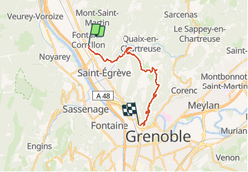

Length
19.8 km

Max alt
1043 m

Uphill gradient
1126 m
Km-Effort
35 km

Min alt
199 m

Downhill gradient
1112 m
Boucle
No
Creation date :
2020-02-23 08:59:12.192
Updated on :
2020-02-23 17:42:22.76
7h46
Difficulty : Medium

FREE GPS app for hiking
 SityTrail
IGN / Geographical institutes
SityTrail Plus
The world is yours!
About
Trail Walking of 19.8 km to be discovered at Auvergne-Rhône-Alpes, Isère, Fontanil-Cornillon. This trail is proposed by morganee.
Positioning
Country:
France
Region :
Auvergne-Rhône-Alpes
Department/Province :
Isère
Municipality :
Fontanil-Cornillon
Location:
Unknown
Start:(Dec)
Start:(UTM)
709220 ; 5014358 (31T) N.
Comments