


cervieres

oak
User
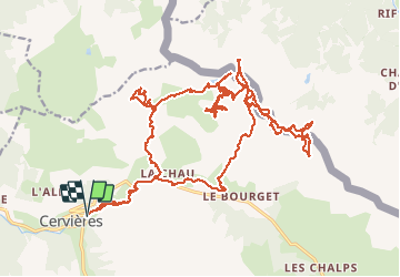

Length
36 km

Max alt
2424 m

Uphill gradient
1814 m
Km-Effort
60 km

Min alt
1639 m

Downhill gradient
1812 m
Boucle
Yes
Creation date :
2020-02-25 08:35:32.643
Updated on :
2020-02-25 20:09:50.982
7h30
Difficulty : Very easy

FREE GPS app for hiking
 SityTrail
IGN / Geographical institutes
SityTrail Plus
The world is yours!
About
Trail Touring skiing of 36 km to be discovered at Provence-Alpes-Côte d'Azur, Hautes-Alpes, Cervières. This trail is proposed by oak.
Positioning
Country:
France
Region :
Provence-Alpes-Côte d'Azur
Department/Province :
Hautes-Alpes
Municipality :
Cervières
Location:
Unknown
Start:(Dec)
Start:(UTM)
320393 ; 4971097 (32T) N.
Comments