


Lesse: Houyet-Gendron-Anseremme

renneph
User
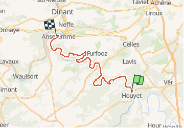

Length
24 km

Max alt
219 m

Uphill gradient
440 m
Km-Effort
30 km

Min alt
93 m

Downhill gradient
459 m
Boucle
No
Creation date :
2020-02-27 09:54:06.216
Updated on :
2020-02-28 08:57:05.576
7h07
Difficulty : Medium

FREE GPS app for hiking
 SityTrail
IGN / Geographical institutes
SityTrail Plus
The world is yours!
About
Trail Walking of 24 km to be discovered at Wallonia, Namur, Houyet. This trail is proposed by renneph.
Photos


Positioning
Country:
Belgium
Region :
Wallonia
Department/Province :
Namur
Municipality :
Houyet
Location:
Houyet
Start:(Dec)
Start:(UTM)
643194 ; 5561734 (31U) N.
Comments