


laquirou

Daron34
User
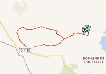

Length
8.2 km

Max alt
103 m

Uphill gradient
102 m
Km-Effort
9.6 km

Min alt
40 m

Downhill gradient
111 m
Boucle
No
Creation date :
2020-02-29 10:43:36.199
Updated on :
2020-02-29 14:10:26.8
2h56
Difficulty : Easy

FREE GPS app for hiking
 SityTrail
IGN / Geographical institutes
SityTrail Plus
The world is yours!
About
Trail Walking of 8.2 km to be discovered at Occitania, Aude, Fleury. This trail is proposed by Daron34.
Positioning
Country:
France
Region :
Occitania
Department/Province :
Aude
Municipality :
Fleury
Location:
Unknown
Start:(Dec)
Start:(UTM)
514879 ; 4783981 (31T) N.
Comments