


Trois Ponts 2020

fra_depoorter
User
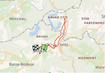

Length
11.9 km

Max alt
349 m

Uphill gradient
290 m
Km-Effort
15.8 km

Min alt
237 m

Downhill gradient
289 m
Boucle
Yes
Creation date :
2020-02-29 08:52:46.279
Updated on :
2020-08-04 13:59:26.535
2h33
Difficulty : Medium

FREE GPS app for hiking
 SityTrail
IGN / Geographical institutes
SityTrail Plus
The world is yours!
About
Trail Walking of 11.9 km to be discovered at Wallonia, Liège, Trois-Ponts. This trail is proposed by fra_depoorter.
Positioning
Country:
Belgium
Region :
Wallonia
Department/Province :
Liège
Municipality :
Trois-Ponts
Location:
Fosse
Start:(Dec)
Start:(UTM)
702616 ; 5583182 (31U) N.
Comments