


2020-02-29_16h40m40_Grignan La Rochecourbière 6km

thonyc
User GUIDE
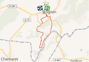

Length
5.3 km

Max alt
210 m

Uphill gradient
87 m
Km-Effort
6.5 km

Min alt
167 m

Downhill gradient
87 m
Boucle
Yes
Creation date :
2020-02-29 15:40:40.92
Updated on :
2020-03-03 09:49:34.623
1h24
Difficulty : Easy

FREE GPS app for hiking
 SityTrail
IGN / Geographical institutes
SityTrail Plus
The world is yours!
About
Trail Walking of 5.3 km to be discovered at Auvergne-Rhône-Alpes, Drôme, Grignan. This trail is proposed by thonyc.
Description
Joli rando avec la visite du village et de La Rochecourbière
Positioning
Country:
France
Region :
Auvergne-Rhône-Alpes
Department/Province :
Drôme
Municipality :
Grignan
Location:
Unknown
Start:(Dec)
Start:(UTM)
651738 ; 4920219 (31T) N.
Comments