


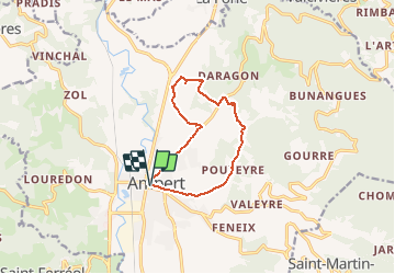
Boucle au dessus d'Ambert

sandra_leb
User

Length
10.3 km

Max alt
627 m

Uphill gradient
188 m
Km-Effort
12.8 km

Min alt
531 m

Downhill gradient
189 m
Boucle
Yes
Creation date :
2020-02-29 18:03:05.857
Updated on :
2020-02-29 18:03:29.535
2h45
Difficulty : Difficult

FREE GPS app for hiking
 SityTrail
IGN / Geographical institutes
SityTrail Plus
The world is yours!
About
Trail Walking of 10.3 km to be discovered at Auvergne-Rhône-Alpes, Puy-de-Dôme, Ambert. This trail is proposed by sandra_leb.
Positioning
Country:
France
Region :
Auvergne-Rhône-Alpes
Department/Province :
Puy-de-Dôme
Municipality :
Ambert
Location:
Unknown
Start:(Dec)
Start:(UTM)
557855 ; 5044305 (31T) N.
Comments