


Sommet de Cornudère

petit-pied
User
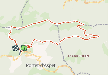

Length
11.9 km

Max alt
1575 m

Uphill gradient
762 m
Km-Effort
22 km

Min alt
1074 m

Downhill gradient
763 m
Boucle
Yes
Creation date :
2020-03-01 00:50:37.064
Updated on :
2020-03-01 00:51:02.557
4h25
Difficulty : Very difficult

FREE GPS app for hiking
 SityTrail
IGN / Geographical institutes
SityTrail Plus
The world is yours!
About
Trail Walking of 11.9 km to be discovered at Occitania, Haute-Garonne, Portet-d'Aspet. This trail is proposed by petit-pied.
Positioning
Country:
France
Region :
Occitania
Department/Province :
Haute-Garonne
Municipality :
Portet-d'Aspet
Location:
Unknown
Start:(Dec)
Start:(UTM)
324911 ; 4756944 (31T) N.
Comments