


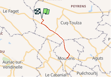
aller retour l'endaydé Mouzens

tabouelle
User

Length
10.4 km

Max alt
287 m

Uphill gradient
95 m
Km-Effort
11.6 km

Min alt
254 m

Downhill gradient
95 m
Boucle
Yes
Creation date :
2020-03-01 09:43:00.9
Updated on :
2020-03-01 12:17:46.604
2h23
Difficulty : Very easy

FREE GPS app for hiking
 SityTrail
IGN / Geographical institutes
SityTrail Plus
The world is yours!
About
Trail Walking of 10.4 km to be discovered at Occitania, Tarn, Cuq-Toulza. This trail is proposed by tabouelle.
Description
rando
Positioning
Country:
France
Region :
Occitania
Department/Province :
Tarn
Municipality :
Cuq-Toulza
Location:
Unknown
Start:(Dec)
Start:(UTM)
407897 ; 4823802 (31T) N.
Comments