


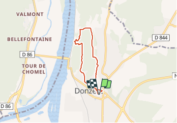
Donzère les falaises 6km

thonyc
User GUIDE

Length
5.4 km

Max alt
170 m

Uphill gradient
131 m
Km-Effort
7.2 km

Min alt
74 m

Downhill gradient
130 m
Boucle
Yes
Creation date :
2020-03-01 14:07:47.138
Updated on :
2022-03-16 18:35:01.794
2h00
Difficulty : Easy

FREE GPS app for hiking
 SityTrail
IGN / Geographical institutes
SityTrail Plus
The world is yours!
About
Trail Walking of 5.4 km to be discovered at Auvergne-Rhône-Alpes, Drôme, Donzère. This trail is proposed by thonyc.
Positioning
Country:
France
Region :
Auvergne-Rhône-Alpes
Department/Province :
Drôme
Municipality :
Donzère
Location:
Unknown
Start:(Dec)
Start:(UTM)
636152 ; 4922525 (31T) N.
Comments
Très belle vue des falaises !!!