


200303 Vauvert Fonteuille

Dupuybadonniere
User
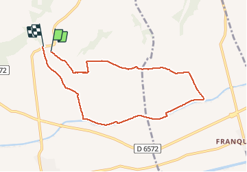

Length
8.6 km

Max alt
55 m

Uphill gradient
98 m
Km-Effort
9.9 km

Min alt
17 m

Downhill gradient
93 m
Boucle
Yes
Creation date :
2020-03-03 08:22:10.639
Updated on :
2020-03-03 10:23:46.917
2h01
Difficulty : Very easy

FREE GPS app for hiking
 SityTrail
IGN / Geographical institutes
SityTrail Plus
The world is yours!
About
Trail Walking of 8.6 km to be discovered at Occitania, Gard, Vauvert. This trail is proposed by Dupuybadonniere.
Positioning
Country:
France
Region :
Occitania
Department/Province :
Gard
Municipality :
Vauvert
Location:
Unknown
Start:(Dec)
Start:(UTM)
604707 ; 4835643 (31T) N.
Comments