


mad utelle pont du croc direct

sylvainstaels
User
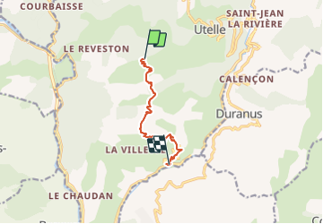

Length
7.6 km

Max alt
1188 m

Uphill gradient
76 m
Km-Effort
11.9 km

Min alt
202 m

Downhill gradient
1061 m
Boucle
No
Creation date :
2014-12-10 00:00:00.0
Updated on :
2014-12-10 00:00:00.0
1h11
Difficulty : Difficult

FREE GPS app for hiking
 SityTrail
IGN / Geographical institutes
SityTrail Plus
The world is yours!
About
Trail Mountain bike of 7.6 km to be discovered at Provence-Alpes-Côte d'Azur, Maritime Alps, Utelle. This trail is proposed by sylvainstaels.
Description
excellent
Positioning
Country:
France
Region :
Provence-Alpes-Côte d'Azur
Department/Province :
Maritime Alps
Municipality :
Utelle
Location:
Unknown
Start:(Dec)
Start:(UTM)
357291 ; 4863264 (32T) N.
Comments