


U2020 6/03 ACS Epinac

clabidault
User
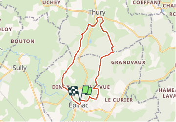

Length
13.7 km

Max alt
460 m

Uphill gradient
214 m
Km-Effort
16.6 km

Min alt
324 m

Downhill gradient
217 m
Boucle
Yes
Creation date :
2020-03-04 12:30:56.024
Updated on :
2020-03-08 20:03:50.352
2h55
Difficulty : Very easy

FREE GPS app for hiking
 SityTrail
IGN / Geographical institutes
SityTrail Plus
The world is yours!
About
Trail Walking of 13.7 km to be discovered at Bourgogne-Franche-Comté, Saône-et-Loire, Épinac. This trail is proposed by clabidault.
Positioning
Country:
France
Region :
Bourgogne-Franche-Comté
Department/Province :
Saône-et-Loire
Municipality :
Épinac
Location:
Unknown
Start:(Dec)
Start:(UTM)
615107 ; 5205247 (31T) N.
Comments