


SityTrail - viessoix01

semaine
User
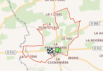

Length
10.9 km

Max alt
226 m

Uphill gradient
167 m
Km-Effort
13.2 km

Min alt
162 m

Downhill gradient
167 m
Boucle
Yes
Creation date :
2020-03-05 15:09:22.352
Updated on :
2020-03-05 15:18:06.254
--
Difficulty : Very easy

FREE GPS app for hiking
 SityTrail
IGN / Geographical institutes
SityTrail Plus
The world is yours!
About
Trail On foot of 10.9 km to be discovered at Normandy, Calvados, Valdallière. This trail is proposed by semaine.
Positioning
Country:
France
Region :
Normandy
Department/Province :
Calvados
Municipality :
Valdallière
Location:
Unknown
Start:(Dec)
Start:(UTM)
661416 ; 5411844 (30U) N.
Comments