


B4280_0025_Creno

c.rendu
User
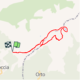

Length
7.7 km

Max alt
1497 m

Uphill gradient
510 m
Km-Effort
14.5 km

Min alt
1008 m

Downhill gradient
511 m
Boucle
Yes
Creation date :
2014-12-10 00:00:00.0
Updated on :
2014-12-10 00:00:00.0
--
Difficulty : Unknown

FREE GPS app for hiking
 SityTrail
IGN / Geographical institutes
SityTrail Plus
The world is yours!
About
Trail Other activity of 7.7 km to be discovered at Corsica, South Corsica, Soccia. This trail is proposed by c.rendu.


Positioning
Country:
France
Region :
Corsica
Department/Province :
South Corsica
Municipality :
Soccia
Location:
Unknown
Start:(Dec)
Start:(UTM)
493152 ; 4671530 (32T) N.
Comments