


Moriani

ferosine
User
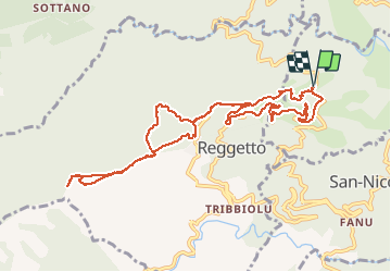

Length
12.1 km

Max alt
999 m

Uphill gradient
744 m
Km-Effort
22 km

Min alt
260 m

Downhill gradient
746 m
Boucle
Yes
Creation date :
2020-03-01 07:34:42.288
Updated on :
2020-03-07 21:51:00.488
6h50
Difficulty : Very easy

FREE GPS app for hiking
 SityTrail
IGN / Geographical institutes
SityTrail Plus
The world is yours!
About
Trail Walking of 12.1 km to be discovered at Corsica, Haute-Corse, Santa-Lucia-di-Moriani. This trail is proposed by ferosine.
Positioning
Country:
France
Region :
Corsica
Department/Province :
Haute-Corse
Municipality :
Santa-Lucia-di-Moriani
Location:
Unknown
Start:(Dec)
Start:(UTM)
540370 ; 4692291 (32T) N.
Comments