


Marat journal 1

jeanic63
User
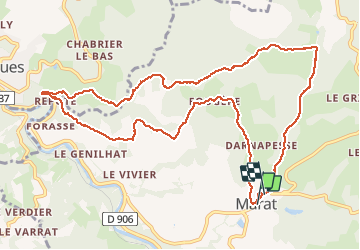

Length
12.8 km

Max alt
686 m

Uphill gradient
429 m
Km-Effort
18.5 km

Min alt
445 m

Downhill gradient
422 m
Boucle
Yes
Creation date :
2020-03-08 07:22:44.025
Updated on :
2020-03-08 10:57:41.743
3h07
Difficulty : Very easy

FREE GPS app for hiking
 SityTrail
IGN / Geographical institutes
SityTrail Plus
The world is yours!
About
Trail Walking of 12.8 km to be discovered at Auvergne-Rhône-Alpes, Puy-de-Dôme, Marat. This trail is proposed by jeanic63.
Description
départ mairie matat
Positioning
Country:
France
Region :
Auvergne-Rhône-Alpes
Department/Province :
Puy-de-Dôme
Municipality :
Marat
Location:
Unknown
Start:(Dec)
Start:(UTM)
553190 ; 5056395 (31T) N.
Comments