


TDB Et6

UDGI54
User
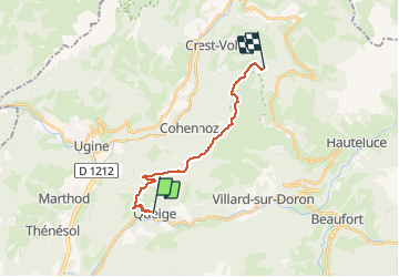

Length
14.8 km

Max alt
1728 m

Uphill gradient
1318 m
Km-Effort
29 km

Min alt
594 m

Downhill gradient
348 m
Boucle
No
Creation date :
2020-03-08 12:40:28.144
Updated on :
2020-03-08 12:41:13.254
--
Difficulty : Very easy

FREE GPS app for hiking
 SityTrail
IGN / Geographical institutes
SityTrail Plus
The world is yours!
About
Trail On foot of 14.8 km to be discovered at Auvergne-Rhône-Alpes, Savoy, Queige. This trail is proposed by UDGI54.
Positioning
Country:
France
Region :
Auvergne-Rhône-Alpes
Department/Province :
Savoy
Municipality :
Queige
Location:
Unknown
Start:(Dec)
Start:(UTM)
302238 ; 5066087 (32T) N.
Comments