


Marche de LAY

perrinfabrice
User

Length
28 km

Max alt
491 m

Uphill gradient
783 m
Km-Effort
38 km

Min alt
270 m

Downhill gradient
675 m
Boucle
No
Creation date :
2019-10-18 21:47:44.0
Updated on :
2020-03-08 12:50:28.517
3h32
Difficulty : Unknown

FREE GPS app for hiking
 SityTrail
IGN / Geographical institutes
SityTrail Plus
The world is yours!
About
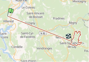
Trail Walking of 28 km to be discovered at Auvergne-Rhône-Alpes, Loire, Villerest. This trail is proposed by perrinfabrice.
Positioning
Country:
France
Region :
Auvergne-Rhône-Alpes
Department/Province :
Loire
Municipality :
Villerest
Location:
Unknown
Start:(Dec)
Start:(UTM)
580114 ; 5094927 (31T) N.
Comments