


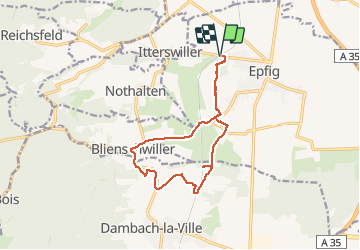
08.02.2020 - Épfig

delm
User

Length
12.6 km

Max alt
260 m

Uphill gradient
209 m
Km-Effort
15.4 km

Min alt
180 m

Downhill gradient
209 m
Boucle
Yes
Creation date :
2020-03-08 13:49:52.0
Updated on :
2020-03-08 16:52:02.97
3h01
Difficulty : Medium

FREE GPS app for hiking
 SityTrail
IGN / Geographical institutes
SityTrail Plus
The world is yours!
About
Trail Walking of 12.6 km to be discovered at Grand Est, Bas-Rhin, Epfig. This trail is proposed by delm.
Description
Trop de parcours le long de la route
Positioning
Country:
France
Region :
Grand Est
Department/Province :
Bas-Rhin
Municipality :
Epfig
Location:
Unknown
Start:(Dec)
Start:(UTM)
385117 ; 5357802 (32U) N.
Comments