


Fleury la Foret

MichelRando7656
User
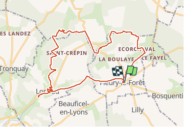

Length
21 km

Max alt
180 m

Uphill gradient
300 m
Km-Effort
25 km

Min alt
95 m

Downhill gradient
300 m
Boucle
Yes
Creation date :
2020-03-08 08:31:03.503
Updated on :
2020-03-08 17:29:11.212
7h39
Difficulty : Medium

FREE GPS app for hiking
 SityTrail
IGN / Geographical institutes
SityTrail Plus
The world is yours!
About
Trail Walking of 21 km to be discovered at Normandy, Eure, Fleury-la-Forêt. This trail is proposed by MichelRando7656.
Description
Sentiers de forets et de campagne
Photos


Positioning
Country:
France
Region :
Normandy
Department/Province :
Eure
Municipality :
Fleury-la-Forêt
Location:
Unknown
Start:(Dec)
Start:(UTM)
395312 ; 5475104 (31U) N.
Comments