


2020-03-07 12:57:10

boularand
User
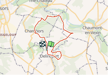

Length
14 km

Max alt
152 m

Uphill gradient
290 m
Km-Effort
17.8 km

Min alt
64 m

Downhill gradient
290 m
Boucle
Yes
Creation date :
2020-03-09 07:45:46.218
Updated on :
2020-03-09 07:50:23.635
3h49
Difficulty : Difficult

FREE GPS app for hiking
 SityTrail
IGN / Geographical institutes
SityTrail Plus
The world is yours!
About
Trail Walking of 14 km to be discovered at Hauts-de-France, Oise, Delincourt. This trail is proposed by boularand.
Photos


Positioning
Country:
France
Region :
Hauts-de-France
Department/Province :
Oise
Municipality :
Delincourt
Location:
Unknown
Start:(Dec)
Start:(UTM)
414809 ; 5455564 (31U) N.
Comments