


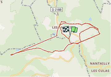
les saisies lund903 apm

jpverteneuil
User

Length
16.7 km

Max alt
1935 m

Uphill gradient
1175 m
Km-Effort
32 km

Min alt
1565 m

Downhill gradient
1174 m
Boucle
Yes
Creation date :
2020-03-09 13:32:17.801
Updated on :
2020-03-09 15:05:51.707
1h31
Difficulty : Very easy

FREE GPS app for hiking
 SityTrail
IGN / Geographical institutes
SityTrail Plus
The world is yours!
About
Trail Alpine skiing of 16.7 km to be discovered at Auvergne-Rhône-Alpes, Savoy, Hauteluce. This trail is proposed by jpverteneuil.
Description
super tombé de la neige.
Positioning
Country:
France
Region :
Auvergne-Rhône-Alpes
Department/Province :
Savoy
Municipality :
Hauteluce
Location:
Unknown
Start:(Dec)
Start:(UTM)
308732 ; 5069766 (32T) N.
Comments