


ITI0024

jeanic63
User
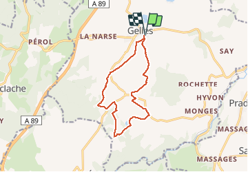

Length
12.5 km

Max alt
974 m

Uphill gradient
244 m
Km-Effort
15.8 km

Min alt
846 m

Downhill gradient
243 m
Boucle
Yes
Creation date :
2020-03-09 19:34:37.223
Updated on :
2020-03-09 19:40:28.693
--
Difficulty : Medium

FREE GPS app for hiking
 SityTrail
IGN / Geographical institutes
SityTrail Plus
The world is yours!
About
Trail On foot of 12.5 km to be discovered at Auvergne-Rhône-Alpes, Puy-de-Dôme, Gelles. This trail is proposed by jeanic63.
Description
A Gelles (à 35 km à l’ouest de Clermont-Ferrand, entre Pontgibaud et Rochefort-Montagne) : parking et panneau de départ face à la Maison familiale et rurale.
Positioning
Country:
France
Region :
Auvergne-Rhône-Alpes
Department/Province :
Puy-de-Dôme
Municipality :
Gelles
Location:
Unknown
Start:(Dec)
Start:(UTM)
481731 ; 5068288 (31T) N.
Comments