


TDA-Boucle-06_30-12-2019

ramagufa
User
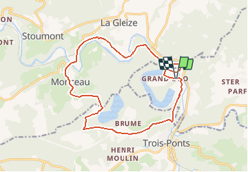

Length
15.8 km

Max alt
498 m

Uphill gradient
461 m
Km-Effort
22 km

Min alt
202 m

Downhill gradient
461 m
Boucle
Yes
Creation date :
2020-03-10 09:40:46.649
Updated on :
2020-03-10 09:44:14.126
--
Difficulty : Medium

FREE GPS app for hiking
 SityTrail
IGN / Geographical institutes
SityTrail Plus
The world is yours!
About
Trail On foot of 15.8 km to be discovered at Wallonia, Liège, Stavelot. This trail is proposed by ramagufa.
Positioning
Country:
Belgium
Region :
Wallonia
Department/Province :
Liège
Municipality :
Stavelot
Location:
Stavelot
Start:(Dec)
Start:(UTM)
704345 ; 5586298 (31U) N.
Comments