![](/images/other/stat-length.png)
![Trail Walking Chennevières-sur-Marne - J 18 12 km Pont de Chennevières - Photo](https://media.geolcdn.com/t/1900/400/ext.pjpeg?maxdim=2&url=https%3A%2F%2Fmedia.geolcdn.com%2Ff%2F6347577b-7c01-4d78-a0ab-c4e201132c35.jpg)
J 18 12 km Pont de Chennevières
Les 1000 pattes
Club randonnées SERVON
![Length](/images/other/stat-length.png)
Length
11 km
![Max alt](https://static1.geolcdn.com/siteimages/upload/files/1508320355ic_sort_altitude_max_24dp.png)
Max alt
54 m
![Uphill gradient](https://static1.geolcdn.com/siteimages/upload/files/1508320355ic_sort_den_pos_24dp.png)
Uphill gradient
75 m
![Km-Effort](/images/other/stat-length.png)
Km-Effort
12 km
![Min alt](https://static1.geolcdn.com/siteimages/upload/files/1508320355ic_sort_altitude_min_24dp.png)
Min alt
31 m
![Downhill gradient](https://static1.geolcdn.com/siteimages/upload/files/1508320355ic_sort_den_neg_24dp.png)
Downhill gradient
71 m
![Boucle](https://static1.geolcdn.com/siteimages/upload/files/16400158638029165_repeat_loop_refresh_sync_direction_icon.png)
Boucle
Yes
Creation date :
2020-03-10 12:31:21.447
Updated on :
2022-12-07 10:05:49.394
![Walking](https://static1.geolcdn.com/sitytour/trail-icons/101.png)
2h43
Difficulty : Medium
![Scan this QR Code to open this trail in the SityTrail application](https://capi.geolives.com/qq0zvz2zws4bq2lad0pu/sitytour/trails/2359698/qr.png?size=200)
FREE GPS app for hiking
About
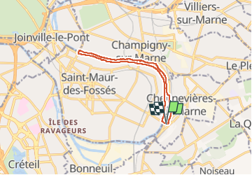
Trail Walking of 11 km to be discovered at Ile-de-France, Val-de-Marne, Chennevières-sur-Marne. This trail is proposed by Les 1000 pattes.
Description
Parking rue de l'Etape Chennevières
bord de marne St Maur Champigny
Positioning
Country:
France
Region :
Ile-de-France
Department/Province :
Val-de-Marne
Municipality :
Chennevières-sur-Marne
Location:
Unknown
Start:(Dec)
Start:(UTM)
464968 ; 5404254 (31U) N.
Comments
Trails nearby
![Trail Walking Noiseau - depuis Noiseau - Photo](https://media.geolcdn.com/t/375/260/ext.jpg?maxdim=2&url=https%3A%2F%2Fservices.sitytrail.com%2FGeolivesWS%2FDownloadMedia.ashx%3FTrailID%3D169363%26Media%3D20130109131150.jpeg)
![Walking Walking](https://static1.geolcdn.com/sitytour/trail-icons/101.png)
depuis Noiseau
Walking
Easy
(2)
Noiseau,
Ile-de-France,
Val-de-Marne,
France
![](/images/other/stat-length.png)
17 km | 19.1 km-effort
4h 35min
![](https://static1.geolcdn.com/siteimages/upload/files/16400158638029165_repeat_loop_refresh_sync_direction_icon.png)
Yes
![Trail Walking Marolles-en-Brie - Balade en forêt Domaniale Notre Dame - Photo](https://media.geolcdn.com/t/375/260/ext.jpg?maxdim=2&url=https%3A%2F%2Fservices.sitytrail.com%2FGeolivesWS%2FDownloadMedia.ashx%3FTrailID%3D340917%26Media%3Dfix__20140831162208.jpg)
![Walking Walking](https://static1.geolcdn.com/sitytour/trail-icons/101.png)
Balade en forêt Domaniale Notre Dame
Walking
Easy
(1)
Marolles-en-Brie,
Ile-de-France,
Val-de-Marne,
France
![](/images/other/stat-length.png)
8.6 km | 9.3 km-effort
2h 3min
![](https://static1.geolcdn.com/siteimages/upload/files/16400158638029165_repeat_loop_refresh_sync_direction_icon.png)
Yes
![Trail Walking Boissy-Saint-Léger - Boissy - Parc Sucy - 15 km - Photo](https://media.geolcdn.com/t/375/260/ext.jpg?maxdim=2&url=https%3A%2F%2Fstatic1.geolcdn.com%2Fsiteimages%2Fupload%2Ffiles%2F1553511878bg_sport_marche.png)
![Walking Walking](https://static1.geolcdn.com/sitytour/trail-icons/101.png)
Boissy - Parc Sucy - 15 km
Walking
Difficult
(1)
Boissy-Saint-Léger,
Ile-de-France,
Val-de-Marne,
France
![](/images/other/stat-length.png)
15 km | 16.7 km-effort
3h 48min
![](https://static1.geolcdn.com/siteimages/upload/files/16400158638029165_repeat_loop_refresh_sync_direction_icon.png)
Yes
![Trail Walking Boissy-Saint-Léger - BM Boissy Sucy 10km reconnaissance - Photo](https://media.geolcdn.com/t/375/260/ext.jpg?maxdim=2&url=https%3A%2F%2Fstatic1.geolcdn.com%2Fsiteimages%2Fupload%2Ffiles%2F1553511878bg_sport_marche.png)
![Walking Walking](https://static1.geolcdn.com/sitytour/trail-icons/101.png)
BM Boissy Sucy 10km reconnaissance
Walking
(1)
Boissy-Saint-Léger,
Ile-de-France,
Val-de-Marne,
France
![](/images/other/stat-length.png)
10.5 km | 11.8 km-effort
2h 23min
![](https://static1.geolcdn.com/siteimages/upload/files/16400158638029165_repeat_loop_refresh_sync_direction_icon.png)
Yes
![Trail Walking Marolles-en-Brie - marolles en brie - Photo](https://media.geolcdn.com/t/375/260/ext.jpg?maxdim=2&url=https%3A%2F%2Fstatic1.geolcdn.com%2Fsiteimages%2Fupload%2Ffiles%2F1553511878bg_sport_marche.png)
![Walking Walking](https://static1.geolcdn.com/sitytour/trail-icons/101.png)
marolles en brie
Walking
Very difficult
(1)
Marolles-en-Brie,
Ile-de-France,
Val-de-Marne,
France
![](/images/other/stat-length.png)
20 km | 22 km-effort
5h 5min
![](https://static1.geolcdn.com/siteimages/upload/files/16400158638029165_repeat_loop_refresh_sync_direction_icon.png)
Yes
![Trail On foot Marolles-en-Brie - L 48 Les Bagaudes et parcours sportif de Sucy 5,7 km - Photo](https://media.geolcdn.com/t/375/260/ext.jpg?maxdim=2&url=https%3A%2F%2Fstatic1.geolcdn.com%2Fsiteimages%2Fupload%2Ffiles%2F1545311037marcheuse_200dpi.jpg)
![On foot On foot](https://static1.geolcdn.com/sitytour/trail-icons/100.png)
L 48 Les Bagaudes et parcours sportif de Sucy 5,7 km
On foot
Easy
(5)
Marolles-en-Brie,
Ile-de-France,
Val-de-Marne,
France
![](/images/other/stat-length.png)
5.5 km | 6 km-effort
1h 21min
![](https://static1.geolcdn.com/siteimages/upload/files/16400158638029165_repeat_loop_refresh_sync_direction_icon.png)
Yes
![Trail On foot Sucy-en-Brie - L 08 Sucy en Brie, parc du Morbras - Photo](https://media.geolcdn.com/t/375/260/ext.jpg?maxdim=2&url=https%3A%2F%2Fstatic1.geolcdn.com%2Fsiteimages%2Fupload%2Ffiles%2F1545311037marcheuse_200dpi.jpg)
![On foot On foot](https://static1.geolcdn.com/sitytour/trail-icons/100.png)
L 08 Sucy en Brie, parc du Morbras
On foot
Very easy
(4)
Sucy-en-Brie,
Ile-de-France,
Val-de-Marne,
France
![](/images/other/stat-length.png)
5.7 km | 6.8 km-effort
1h 46min
![](https://static1.geolcdn.com/siteimages/upload/files/16400158638029165_repeat_loop_refresh_sync_direction_icon.png)
Yes
![Trail Walking Marolles-en-Brie - Rando tuto Martine forêt Notre Dame 10 km - Photo](https://media.geolcdn.com/t/375/260/ext.jpg?maxdim=2&url=https%3A%2F%2Fstatic1.geolcdn.com%2Fsiteimages%2Fupload%2Ffiles%2F1553511878bg_sport_marche.png)
![Walking Walking](https://static1.geolcdn.com/sitytour/trail-icons/101.png)
Rando tuto Martine forêt Notre Dame 10 km
Walking
Medium
(1)
Marolles-en-Brie,
Ile-de-France,
Val-de-Marne,
France
![](/images/other/stat-length.png)
10 km | 10.6 km-effort
2h 24min
![](https://static1.geolcdn.com/siteimages/upload/files/16400158638029165_repeat_loop_refresh_sync_direction_icon.png)
Yes
![Trail On foot La Queue-en-Brie - L 16 5km parking marmouset la queue en brie - Photo](https://media.geolcdn.com/t/375/260/ext.jpg?maxdim=2&url=https%3A%2F%2Fstatic1.geolcdn.com%2Fsiteimages%2Fupload%2Ffiles%2F1545311037marcheuse_200dpi.jpg)
![On foot On foot](https://static1.geolcdn.com/sitytour/trail-icons/100.png)
L 16 5km parking marmouset la queue en brie
On foot
Very easy
(3)
La Queue-en-Brie,
Ile-de-France,
Val-de-Marne,
France
![](/images/other/stat-length.png)
5.2 km | 5.5 km-effort
Unknown
![](https://static1.geolcdn.com/siteimages/upload/files/16400158638029165_repeat_loop_refresh_sync_direction_icon.png)
Yes