


2020-03-11_11h51m51_0_01758 - Le Chemin des Fées

raab
User
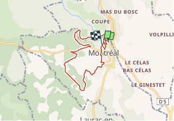

Length
7.5 km

Max alt
316 m

Uphill gradient
214 m
Km-Effort
10.3 km

Min alt
186 m

Downhill gradient
214 m
Boucle
Yes
Creation date :
2020-03-11 10:51:52.03
Updated on :
2020-03-11 10:51:54.131

FREE GPS app for hiking
 SityTrail
IGN / Geographical institutes
SityTrail Plus
The world is yours!
About
Trail of 7.5 km to be discovered at Auvergne-Rhône-Alpes, Ardèche, Montréal. This trail is proposed by raab.
Positioning
Country:
France
Region :
Auvergne-Rhône-Alpes
Department/Province :
Ardèche
Municipality :
Montréal
Location:
Unknown
Start:(Dec)
Start:(UTM)
602712 ; 4931436 (31T) N.
Comments