


notre dame 113 Av midi

jpverteneuil
User
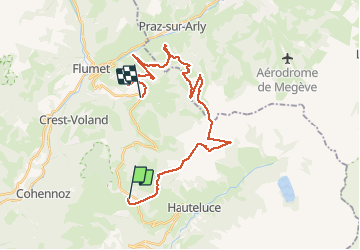

Length
29 km

Max alt
2042 m

Uphill gradient
2564 m
Km-Effort
64 km

Min alt
1029 m

Downhill gradient
2848 m
Boucle
No
Creation date :
2020-03-11 08:02:53.55
Updated on :
2020-03-11 11:04:19.77
2h59
Difficulty : Very easy

FREE GPS app for hiking
 SityTrail
IGN / Geographical institutes
SityTrail Plus
The world is yours!
About
Trail Alpine skiing of 29 km to be discovered at Auvergne-Rhône-Alpes, Savoy, Hauteluce. This trail is proposed by jpverteneuil.
Description
flocloriqu
Positioning
Country:
France
Region :
Auvergne-Rhône-Alpes
Department/Province :
Savoy
Municipality :
Hauteluce
Location:
Unknown
Start:(Dec)
Start:(UTM)
308739 ; 5069782 (32T) N.
Comments