


monastère de Parménie depuis la mairie de tullins par les chemins

trailer38
User

Length
4.2 km

Max alt
729 m

Uphill gradient
470 m
Km-Effort
8.9 km

Min alt
256 m

Downhill gradient
7 m
Boucle
No
Creation date :
2020-03-11 17:12:05.103
Updated on :
2020-03-11 18:00:00.234
1h15
Difficulty : Very easy
45m
Difficulty : Very easy

FREE GPS app for hiking
 SityTrail
IGN / Geographical institutes
SityTrail Plus
The world is yours!
About
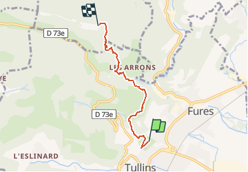
Trail Walking of 4.2 km to be discovered at Auvergne-Rhône-Alpes, Isère, Tullins. This trail is proposed by trailer38.
Description
monastère de Parménie depuis la mairie de tullins par les chemins
Positioning
Country:
France
Region :
Auvergne-Rhône-Alpes
Department/Province :
Isère
Municipality :
Tullins
Location:
Unknown
Start:(Dec)
Start:(UTM)
694824 ; 5019554 (31T) N.
Comments