


stgervais plainejoux anterne

coglais
User
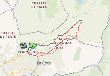

Length
14.7 km

Max alt
2029 m

Uphill gradient
827 m
Km-Effort
26 km

Min alt
1295 m

Downhill gradient
827 m
Boucle
Yes
Creation date :
2020-03-12 10:17:51.289
Updated on :
2020-03-12 10:19:25.987
6h00
Difficulty : Difficult

FREE GPS app for hiking
 SityTrail
IGN / Geographical institutes
SityTrail Plus
The world is yours!
About
Trail Nordic walking of 14.7 km to be discovered at Auvergne-Rhône-Alpes, Upper Savoy, Passy. This trail is proposed by coglais.
Positioning
Country:
France
Region :
Auvergne-Rhône-Alpes
Department/Province :
Upper Savoy
Municipality :
Passy
Location:
Unknown
Start:(Dec)
Start:(UTM)
324828 ; 5091098 (32T) N.
Comments