


Rocamadour 12 mars 20

jacquesduchesne
User
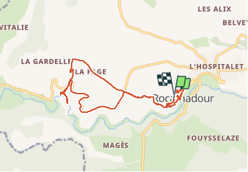

Length
9.6 km

Max alt
266 m

Uphill gradient
333 m
Km-Effort
14.1 km

Min alt
126 m

Downhill gradient
325 m
Boucle
Yes
Creation date :
2020-03-12 08:44:52.79
Updated on :
2020-03-12 11:46:28.029
3h00
Difficulty : Very easy

FREE GPS app for hiking
 SityTrail
IGN / Geographical institutes
SityTrail Plus
The world is yours!
About
Trail Walking of 9.6 km to be discovered at Occitania, Lot, Rocamadour. This trail is proposed by jacquesduchesne.
Positioning
Country:
France
Region :
Occitania
Department/Province :
Lot
Municipality :
Rocamadour
Location:
Unknown
Start:(Dec)
Start:(UTM)
390545 ; 4961583 (31T) N.
Comments